|
Nederlands
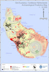
Sint Eustatius, Caribbean Netherlands
Archaeological Predictive Map
In 2013 ARGEOgraph created the Archaeological Predictive Map of Sint Eustatius for the Dutch ministry of Education, Culture and Science. This map has been made available to the Sint Eustatius Center for Archaeological Research (SECAR) and the Sint Eustatius Planning Office in GIS format (shape files) and in A3 (scale 1 : 25 000) and B1 format (1 : 10 000). The pdf files of these maps can be downloaded below. Additionally, a colophon presenting information on approach, sources and precision can be downloaded.
A3 paper size map
B1 poster size map
Colophon
|
|